Friday, July 30, 2010
Trans Alaska Pipeline
John had two major items on his list to see while in Alaska; Mt.McKinley and the Alaskan pipeline. . Yesterday we drove out to see the pipeline.There we were able to get all the facts on the pipeline which I will share with you, and hopefully it won't be too boring.
 As I mentioned in another posting, oil has defined the economy for Alaska since it started flowing from the fields of Prudhoe Bay in 1977. There is a consortium which own TAPS (Trans Alaska Pipeline System). BP Pipelines Alaska has 46.9%, Conoco Phillips has 28.9%, the rest is owned by three other oil companies. Production is now only about one-third of what it was at its peak in 1989, which impressed on me the fact that our natural resources always have an end point. TAPS currently supplies 15% of the U.S. oil production. There were many technical challenges when the pipeline was built. Moving hot oil across the permafrost soil of Alaska presented a special challenge. Large segments of the trans-Alaska pipeline were elevated above ground to keep the permafrost from melting. About half of the pipeline was buried in the conventional manner.
 There were 800 rivers to cross and three mountain ranges. Also 554 animals crossings had to be considered. You may notice structures that look like bumpers on the sides of the pipeline. That allows for some flexibility when earthquakes occur. There are constantly also the technical challenges of low throughput (wax and water buildup,frost heaves,ice crystals and plugs,etc). Since the construction of the pipeline pigs have been used to keep the flow going. Pigs are polyurethane cleaners which flow with the oil and prevent wax build up. Below is a picture of one of those pigs. I found all this information on the pipeline more interesting than I expected it would be. It will give me something to ponder on the next time I pump gas.

Thursday, July 29, 2010
Georgeson Botanical Gardens
These gardens are located on the campus of the University of Alaska, Fairbanks. The gardens are small, at least in comparison to other botanical gardens which we have toured. Maybe I should not attempt any comparison to other botanical gardens considering the geographical area which we are in. And yet, given that Fairbanks does deal with some very long and cold winters, it is amazing to see the flowers and vegetables which are able to flourish during the summer months. It is the midnight sun which makes it possible. According to the AAA Tour Book, the northernmost regions of Alaska receives almost 3 months of continuous sunlight a year. There are many beautiful flower beds at Georgeson. I don't believe I have ever seen the kind of daisies pictured below.
 Flowers are the primary show at the gardens. But research is also going on in the gardens to discover ways that vegetables can grow in the short summer months. Cabbages do quite well here, we are starting to see them in the local farmer's markets. Lots of sauerkraut is sold in Alaska.
 We have not been to find good home-grown tomatoes in Alaska, they are grown in hot houses. Corn is another vegetable that needs a long time under a warm sun. So I was surprised that the university has found a way to grow corn. To get corn, and many other vegetables to grow, the soil temperature needs to be raised. This is done by various methods as plastic mulch, styrofoam insulation, cold frames and hot beds. The vegetables are also planted in rows from east to west to get the southern exposure. I was impressed with the corn which is now on the stalks in the garden. The plants are small but the corn is quite filled out.
 I guess that I have bored some of you enough with gardening information. Probably you are not interested unless your are into plying a spade into soil. I am interested because there has been a paucity of fruits and vegetables available for us here in Alaska, unless we are willing to pay the high prices. At the Fairbank's farm market yesterday tomatoes were priced from $5-6.00 a pound, and all were from hot houses. I need to end this posting on a bit more interesting but humorous note. A street we passed yesterday was called "Stubborn German Court". Coincidentally, I am sure, it is across the street from Zion Lutheran Church in Fairbanks.


North Pole Alaska
In reality we are parked 150 miles south of the Arctic Circle at present. We are next to Santa Claus House, home of the original letter to Santa and deed to one square inch of North Pole.
 This is the most far north which we have come so far and, when we arrived Monday, we could not get into our shorts fast enough! It was the first real summer day we have had so far in Alaska. We are about fifteen miles from Fairbanks, a city known for its extreme weather. It can be -60 degrees in the winter and 95 degrees on a summer day. Whatever the explanation is for its weather proclivities, we are just happy to feel warm again. Tuesday we drove to the Morris Thompson Cultural and Visitors Center in historic Fairbanks. I was just amazed at the beautiful flower gardens there. How did those flowers manage to bloom with the cloudy, wet, cool weather we have been having? Only explanation I have for that is the long days of sunshine, few though they may be.
 The visitor's center has exhibits pertaining to the public lands and parks of Alaska, also movies on life in Alaska- both past and present. I did not realize that Fairbanks is noted for its winter sports as cross-country and downhill skiing, curling, ice hockey and dog mushing. I also learned at the center how the Alaskan pipeline saved the economy of Alaska and helped the state to improve its primitive infrastructure in the 1960s. While we were at the center we were treated to a concert provided by the Fairbanks Summer Arts Festival. We heard some classical offerings provided by violin, cello and bass cello performers. That was an unexpected treat. From the visitor's center we walked over to the Golden Heart Plaza where there was a memorial to the pioneers of Alaska. As you can see by the picture, we were having another cloudy day. At least it was not raining!


Saturday, July 24, 2010
McKinley Station Trail in Denali Park
Just within the entrance to Denali Park there are hiking trails available. Taking one of those trails was a better option for us rather than paying the fee for another bus ride into the interior of the park. Wildlife can be found anywhere in the park. We can always count on seeing a moose and right now the bears are roaming everywhere in search of the summer berries which are now ripe. One type of berry they are after at present is the soapberry, pictured below. Our hike yesterday was led by a park ranger and she pointed out this plant, as well as many others, to us. We were quite fortunate to run into her tour group at the beginning of our hike.
 Sandy, our guide, pointed out the crowberry and cranberry bush plants when we passed by them on our hike. While we were walking along with her a park maintenance man came up to us and said that he had just come within about six feet of a bear. The location was along the trail we were taking. Needless to say, the ranger had us detour away from that area. Sandy was very knowledgeable about many of the plants which we saw on the trail. Her college majors were in biology and anthropology. She shared with us some very interesting history about the people who once lived in the park during the 1920s. One particular area is called "The Hole". This was a town once popular for wine, prostitutes and gambling. Tin can middens are still lying around the places where once there had been homes and stores. Wildflowers were abundant along our trail. I was really impressed by the tall larkspur. That is actually its name, and you can see why in the picture below. The pink flower below it is fireweed, the most frequently seen blooming flower at present in the park.
 Sandy was also knowledgeable about the wide variety of mushrooms which we saw on the trail. She broke open a couple and pointed out the various physical features of the fungus which either made it poisonous or non-poisonous. On this trail, and another one which we took later, I saw mushrooms of every shape and color. That really is a mushroom in the picture below. I touched it to make sure, at first glance it looked like a big rock!
 After we had completed the ranger-led hike we went off on our own and hiked to Horseshoe Lake. At the far end of it is a large beaver dam which seems to be a couple hundred of feet long. As we were gazing at the lake a beaver swam over to the dam, walked over it and swam off on the other side. Below is a picture of the first sighting of Horseshoe Lake which I took from an overlook on our trail. There are a couple of islands in the lake.


Friday, July 23, 2010
An Alaskan Summer Day
It is very difficult for me to get any sense of what season we are in. We have had many cool wet days, which reminds me of spring. The weather man on a local station says Alaska is getting an early fall. The first snowfall may be a month or so away. Animals are busy eating and storing food for the winter, which we saw in the park Wednesday. Then again, a lot of wildflowers are out and berries are starting to ripen. Not only are we finding blueberries to eat while hiking, but yesterday we found some ripe raspberries. And the little bee drawing nectar from a yarrow flower, in the picture below, presented a scene more common in the summer time.
 We were not sure what the weather was going to do yesterday. At least it was not raining, so we headed out for a hike on a path across the highway from where we are parked. Initially we came upon a big gravel pit which possibly the highway department is mining for its use. Scattered around that area are many rock and large boulders. It was tempting to pick up the many beautiful agates lying around, but that is something which I am not doing anymore. To satisfy myself, I did pocket one small stone. The whole area seemed to have the debris of a glacial moraine; such as gravel,sand and silt. Also scattered around were a few large boulders as the one seen in the picture below. That boulder could be a glacial erratic, rock which had been avalanched onto an ancient glacier and transported beyond its source. John was very fascinated with the structural features of the rock, as well as the large crystals lying on its surface.


After traversing through the dry rocky area we soon found ourselves hiking into a forest. Humans had been through this area before; we noted an old sofa bed sitting a short distance from our path. After climbing up a couple of hills we were rewarded with the sight of a beautiful valley spread out below us.

Thursday, July 22, 2010
Denali National Park
Yesterday morning was cloudy, cold and wet. We could not even see the mountain ranges surrounding our home. And yet, for some strange reason, we did head out for the park. The weather forecast looked the same for the rest of the week; clouds and showers every day. We also figured that rain doesn't influence the activities of the wildlife. It did turn out to be an awesome day for wildlife viewing. In fact, according to our bus driver Jim, it was a phenomenal day and one of the best days for him in the 30 some years he has been driving in the park. Many national parks have interesting wildlife, but the Denali wildlife community is unique in that it has remained intact over the years. All of the plant and animal species are present, and no species have had to be reintroduced. We took the tour which would end at Eielson Visitor Center, a road trip of 66 miles into the interior. It was a slow eight hour journey over a gravel one-lane road. In some areas the bus climbed up steep narrow mountain passes where occasionally it was necessary for our bus to move to the edge of the road to let another bus pass. Those were the times when I just needed to close my eyes and not look out!
 Shortly after we had started out someone spotted a bull moose out in the woods. Our driver stopped, peered out with his binoculars and commented that it was a 5 or 6 six year-old bull moose enjoying a meal of willow leaves.Fortunately the moose stopped grazing for a few minutes to pose for us.

The scenery of the park is beautiful. We traveled through lowland taiga forest as well as barren tundra meadows. The 650-mile-long mountain chain, known as the Alaska Range, passes through the park. Glaciers on those mountains have have carved out beautiful valleys in the park as well as bringing about some awesome rock formations. Many other geologic events also account for the spectacular beauty of the park. Below is a picture I took at the Polychrome Rest Area, given that name because of the varied colors of the rock layers in the hills. I was totally mesmerized by all that beauty!
 A very familiar bird of this region is the willow ptarmigan. It is Alaska's state bird. We had a couple sightings of him, as well as a harrier hawk. We saw Dall sheep high up on a rocky hillside, and a wolf with its three young kits crossed the road in front of us. Even more exciting was seeing grizzly bears at three different times on our journey. It was always a mama bear with her cubs. I was able to get a fairly good picture of one family because they started heading toward the bus. Mama bear did not like the hiker standing outside our bus, maybe that is why she headed our way. Once the hiker stepped into our bus for a few minutes, she headed back to the meadow from where she had come from.
 We also saw a herd of around 40 caribou grazing on a treeless ridge of a hillside. Their silhouettes stood out starkly against what was then a blue sky. Our driver Jim said he rarely sees such a large number in one place. At Eielson Visitor's Center, as I was heading back toward the bus, I happened to glance over the hillside and saw a red fox scurrying down toward the river. During the day many ground squirrels were seen along the road.. In fact, enough of them to keep all the bears, wolves and foxes well fed! The showers came and went all day, which made it necessary to clean our windows at every rest stop. We had dark cloudy skies as well as a few bursts of sunshine. No remote chance of seeing Mount Mckinley. Despite the weather we still had a fantastic trip into the Denali Park.


The scenery of the park is beautiful. We traveled through lowland taiga forest as well as barren tundra meadows. The 650-mile-long mountain chain, known as the Alaska Range, passes through the park. Glaciers on those mountains have have carved out beautiful valleys in the park as well as bringing about some awesome rock formations. Many other geologic events also account for the spectacular beauty of the park. Below is a picture I took at the Polychrome Rest Area, given that name because of the varied colors of the rock layers in the hills. I was totally mesmerized by all that beauty!


Savage River Valley
Yesterday afternoon we made our first foray into Denali National Park. The visitor's center has lots of information specific to the park, especially on the wildlife which exist there. We also were able to view a movie on scenes of the park during the four seasons, and a ranger gave a talk on the glaciers which are located in the park. Most vehicles can only drive fifteen miles into the park, which is the Savage River valley. From that point on there is a guard gate and only gravel roads. Below is a picture of the river valley, quite a picturesque area.
 There is one large rock formation which dominates this river valley. My brother Wayne and I hiked up to the base of the top ridge. Below is a picture which I took from this viewpoint. A corner of that rock is shown in the picture below.
 In the Savage River valley where we hiked yesterday there are quite a few wildflowers. Because of the short growing season they do not grow very tall but still managed to catch my attention yesterday with their striking colors. In the picture below there is the blue harebell, the white narcissus anemone and the shrubby yellow cinquefoil. Today we took a bus trip further into the interior of the park. More on that in my next posting.
 On our way out of the park last evening we stopped at an overlook which was supposed to provide us a good view of the big mountain, Denali. Fortunately we were able to get a small glimpse of it. In the picture below it is the white half circle behind the mountain range in the foreground. If we get a clear day before we leave the area I may yet get a better picture of it.


Wednesday, July 21, 2010
Parks Highway to Healy
We left Talkeetna yesterday and drove north to Denali National Park. We soon found ourselves on winding hilly roads, passing through some very scenic river canyons. The first bridge we crossed was over Hurricane Gulch, which rises some 260 feet above Hurricane Creek. That canyon was absolutely breath-taking to see. It was shortly after we crossed the Chulitna River that we started getting dramatic views of the Alaskan Range. We pulled over a few times to see if we could view Mt.Mckinley but the weather was not cooperating. The rain which had started on Sunday was letting up but we still had cloudy skies. We had read somewhere that during the summer on every two out of three days Mt Mckinley is behind clouds! Nevertheless, our drive Monday was still awesome. Toward the end of our journey we came to the area of Broad Pass, one of the most scenic places on Parks Highway. It is a mountain valley, bare in some places and in others dotted with shrub spruce and surrounded by mountain peaks. And I was surprised to see dry land- no water puddles lying around. I was able to get some pictures once we finally stopped at our rv park, which is located about eight miles north of Denali Park.
 Our home is now sitting in a mountain valley with Antler Creek flowing by it. Shortly after we parked, John, my brother Wayne and I took Antler Trail and hiked up to the closest mountain ridge. Below is a picture of the creek as we looked down at it.
 While on our hike I also took a picture of cotton grass. There are 14 varieties of this grass in Alaska. Early settlers and Native Indians use to stuff their pillows with the cotton, and the plant also has some medicinal uses. The other plant we found on our hike was low bush blueberries, now ripe enough to eat.


Saturday, July 17, 2010
Talkeetna Museum


Talkeetna Alaska


Friday, July 16, 2010
Whittier Alaska
As I mentioned in the last posting, Whittier is a harbor town on Prince William Sound. Prior to the construction of the Whittier spur road, this town was accessible overland only train. A major project during construction of the Whittier access road was the modification of the 2.5 mile-long Anton Anderson Tunnel to handle both railroad and vehicle traffic. Vehicles must wait in a staging area on either end of the tunnel when the train is using the tunnel. Tunnel tolls are charged according to vehicle class and are round-trip. It was interesting to drive through a train tunnel. It mainly amounted to riding the tracks, which can be a bit slippery at times because of moisture in the tunnel. We were given instructions to keep at least 100 feet distance from the car in front of us.

Whittier is very much an isolated community. It was created by the U.S. army during WW11 as a port and petroleum delivery center. At this time it had a population of 1200. It now has a population of 170. Its economy rests largely on the tourism and on the fishing industry. We did find enough to do what with wandering through the gift shops and touring the Prince William Sound Museum. The museum featured information about Whittier's connection to the millitary and WW11. It also had historical information on other areas of Alaska. I had never before given much thought about the importance of its geographical location during the cold war years. The town is nestled at the base of many snow -covered mountains which are quite scenic with their numerous waterfalls. The one below is quite large and splashes down quite dramatically on the snow below it.

One other beautiful scenic view we had on the Seward Highway coming out of Whittier was the Billing's Glacier, also pictured below.

Wednesday, July 14, 2010
Alaska Wildlife Conservation Center
This was a great place to visit. The center provides rehabilitation of orphaned and injured animals. It works with state and federal agencies providing wildlife emergency treatment, rescue and care. We saw the bear cubs which the center has raised after their mother had been shot. They are called Joe Boxer and Hugo. Joe Boxer is pictured below.
 The first wood bison in Alaska for more than 100 years was born at this center in 2005. Also at this center are Sitka black-tailed deer, moose, elk, and caribou. I am still trying to learn the differentiation between the last three. Pictured below is a moose.
 And the other picture is that of a caribou. What a big difference in the antlers!
 Caribou are also reindeer. The male of that species looses his antlers in the fall and the female looses hers in the spring. I guess that makes Rudolph the Red Nose Reindeer a female! That was a little nugget of information I picked up at the center. The town of Portage, now no longer in existence, use to lie on the grounds of the center. A lot of the town slid into the waters of Turnagain Arm during the earthquake of 1964.
One of the cabins is still lying at the water's edge, we saw it while touring the grounds of the center.
 From the center we drove on to the Whittier Harbor, which is the gateway to Prince William Sound. More on that in my next posting.


One of the cabins is still lying at the water's edge, we saw it while touring the grounds of the center.

Monday, July 12, 2010
Mt. Marathon
Before heading out to do some hiking this afternoon we attended church in Seward at Resurrection Lutheran. Below is a picture of the sanctuary of the church. It struck me as looking quite simple and yet very beautiful.
 Please note the two poinsettia plants on the altar. It is just things like that here in Alaska which constantly confuse me and make me wonder what season we are in! Just kidding, seeing those plants in July did make me chuckle. After the service a wonderful lunch was was served to everyone and I had a chance to speak with the pastor. I found out that Pastor Ron Nitz was a classmate of my brother Marcus at the seminary in St.Louis. After lunch John, my brother Wayne and I drove to Mt. Marathon, the trails of which are located in Seward. For many years Seward has held a run up that mountain on July 4th. It was last Sunday when 3,000 runners converged on the town for that run. We met a man at church who has done the run for over 20 years(said he won the race three times over the years). He warned us not to try to hike the first part of the run because it would require us climbing up shear cliffs. John attempted to hike up that slope but did turn around when he reached the first large rock to climb over. That is John in the lower left corner of the picture below.
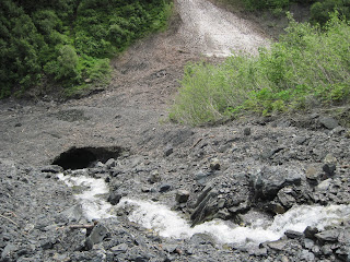
 We didn't even attempt to climb that mountain as it seemed just as interesting to walk in the river canyon below it. We soon discovered that the canyon was a glacial moraine with many small streams and waterfalls. We could see high above us the icefield, and flowing from that a narrow stream of water coming down the side of the mountain. It looked like white gravel at the bottom but instead it was ice. As we hiked closer to that area of ice we started finding the ground below getting less solid. Poking around on the gravel and mud with our walking sticks we discovered that we were walking on chunks of ice. The picture below should give you an idea of what I am referring to.
 In that area were a couple of ice caves/tunnels from which more streams of water flowed.
 It was not until we had looked back at the second ice cave that we realized we had been walking above it and could have easily fallen through the roof of the cave. Thinking about that possibility was a bit scary as we did not know how deep that underground tunnel went! The whole area was interesting to explore, just to see the large amount of brush and stone that gets pulled down and piled up over the years by snow and ice. It was quite a delightful hike, topped only by the gorgeous sunlight shinning down on us. So many townspeople commented to us how they too were enjoying the sunshine. The last picture is of my brother and I along the trail.


Saturday, July 10, 2010
A Sunny Day on the Kenai Peninsula
We have had a couple of sunny days here, so I thought I needed to show again the area we are in without the cloud cover over the mountains. What a dramatic view we get when the clouds are gone and the snow- mountains can stand out in all their glory against the blue sky! And,yes, that is our home in the lower right hand corner.
 We had sunshine for half of the day yesterday so we drove out to Kenai Fjords National Park to look at the Exit Glacier again. While driving back out of that area we noticed another glacier coming off the Harding Icefields. It stretched down the full length of the mountain. What an stunning sight!
 We also walked around the town of Seward again. Seward Community Library shows a film of the earthquake of 1964 daily in the afternoon which we stopped to see. When the earthquake happened the oil company in town immediately burst into flames, and, if that wasn't bad enough, tsunami waves from the ocean then rolled over the town. So it was not surprising to find that many of the buildings in town have been built since 1964. Below is a street scene of Seward. The building in the foreground,with the mural, is the sea aquarium. Quite a few murals can be found on various buildings in Seward.
 Monday we will be heading out of this area and driving north to Hope Alaska.


Thursday, July 8, 2010
Kenai Fjord Cruise, Part Two
I have seen bald eagle before, but never heard their particular cry. There is one eagle that flies around our campground occasionally and I have noticed that he does make some noises while in flight. It is kind of a chirping sound, as well as a low trill. On our trip through the fjords yesterday we did see bald eagles and other birds. In fact, I also saw my first tufted puffin swimming in the bay. He is quite colorful with tufts of yellow feathers adorning his face. On our cruise we passed by a rookery completely covered with cormorants, murres, kittiwakes, and many other different kinds of sea birds who enjoy the rich feeding ground of the bay. I mentioned in the last posting that on this cruise we passed by some massive glaciers. The first was Bear Glacier Point. It is the largest one of those found in the Harding Ice Fields. Three smaller glaciers feed into it. The black line in its middle is a moraine. It is 13 miles long. It may look small here, but it was quite some distance from us.
 The glacier which was most impressive for us was the Aialik Glacier because we could come close to it, hear the ice cracking, and see the boulders caving off from it. Below is a picture of one of those icebergs lying close to the boat. There were lots of smaller chunks also lying around in the water. The air felt a lot colder in this region.
 Aialik Glacier is a tidewater glacier because it terminates at sea level and calves directly into an ocean. Seeing it up close was quite impressive, probably more so than Exit Glacier which we saw the other day.
 The ship's crew brought in one large ice berg, chipped it up and put them in margaritas which we enjoyed. The ice chips were amazingly clean and clear. Also quite cold! One last picture I have is that of a small island which we passed. Most of its trees were dead and sun bleached. Teutonic activity (earthquake of 1964) caused the land to sink, allowing saltwater to inundate the roots leaving "ghost trees" standing.
 You probably have figured out by now that we did not have a very good day as far as the weather went. Actually, I did not notice or was bothered by the weather because there was so much to see in the seven hours we were on the boat. Well, there were a couple of times when the weather was an issue. That was when the storm came in, whipped up the waves and rocked the boat. Amazingly between bouts of stomach queasiness, I somehow managed to eat the delicious meal and deserts which were served during the course of the trip. It was a fantastic trip and impressed on me how important it is to take good care of our planet.


Subscribe to:
Posts (Atom)
